
Every campground and dispersed site in the US,
and the road worth taking to it.
Describe the trip in one sentence and get a real route back: dirt where you want it, the detours worth taking, and a camp at the end of the day. Rated for what you're travelling on, enduro bike to RV, and it all still works with no signal.
- 57,000campgrounds and
dispersed sites - 70,000points of interest
worth the detour - 7,000rest areas and
overnight stops - 50states, one
map
Not the fastest way. The best route.
Every other map routes you the quick way through. This one is built for adventure travel: it'll put you on dirt, over the pass, and at a camp you would never have found on your own.
🧭 It takes the roads other maps avoid
Prefer dirt, prefer twisty, or avoid highways, and forest roads and motorised trails are rated for what you're actually in, from RV to enduro bike. The back way over the divide becomes a decision instead of a gamble.
🔦 It finds what you would have missed
Hot springs, waterfalls, lookouts, ghost towns and backcountry huts near your line, offered as detours before you commit, and dispersed camping on public land waiting at the end of the day.
✨ Nothing mainstream does both
Describe the trip in a sentence and get real routes back. No other mainstream map does that, none of them rate a road for your vehicle, and none of them finish the route at a bed.
Tell it what you're on. The route changes.
Eight rigs, one map. Same two towns, different line, because a loaded RV and a KTM don't fit down the same road.
Pedal or e-bike. Cycleways, rail trails and quiet lanes, never a freeway, and never the wrong way down a one-way.
Singletrack is the objective, not a penalty. Rough trail and grade 4 to 5 track get sought out rather than avoided.
Loaded dual-sport. Good gravel yes, singletrack no; 250kg of bike and panniers is the difference.
Narrow, and rough ground is the point. ATV-only trails read as open, because on a UTV they are.
Roof tent assumed at 7'7" tall. Posted height, width, length and weight limits are checked along the whole route.
Tall and long. Capable of most of it, but the low bridge and the tight switchback start deciding the route for you.
Clearance and length rule everything. Kept off the jeep trails the enduro bike is sent looking for.
Always routed as towing: no soft ground and no dead ends, because reversing a trailer back out of one is the real risk.
Two levels, on purpose. Save the rig you usually travel in, then override it for one route without touching that default; the same person plans a singletrack day and a tow-the-trailer highway slog in the same week. Towing is a tick rather than a ninth option, and it changes the route on its own: length, weight, and the switchbacks you could take solo.
Towing? Take the easy road. Pick RV or Travel trailer and the app plans the gentlest road there is: main roads, no steep descents, no hairpins, even when that's a lot further. Durango to Ouray goes round the San Juans instead of over the Million Dollar Highway: main roads at 7% or less, instead of 8% grades, hairpins and a sheer drop with no guardrail. A 40-foot fifth wheel, a toy hauler or a long travel trailer is also routed around posted length limits and roads closed to trailers by rule, 2,276 signed stretches across the US read from the map itself. If there's no gentler road, it says so. Rather take the short way? One switch turns it off.
See the storm coming. Keep the forecast when the signal goes.
Live rain radar over the whole country, refreshed while you watch it, and the seven-day forecast for your route stored on the phone so it still answers you in a canyon with no bars.
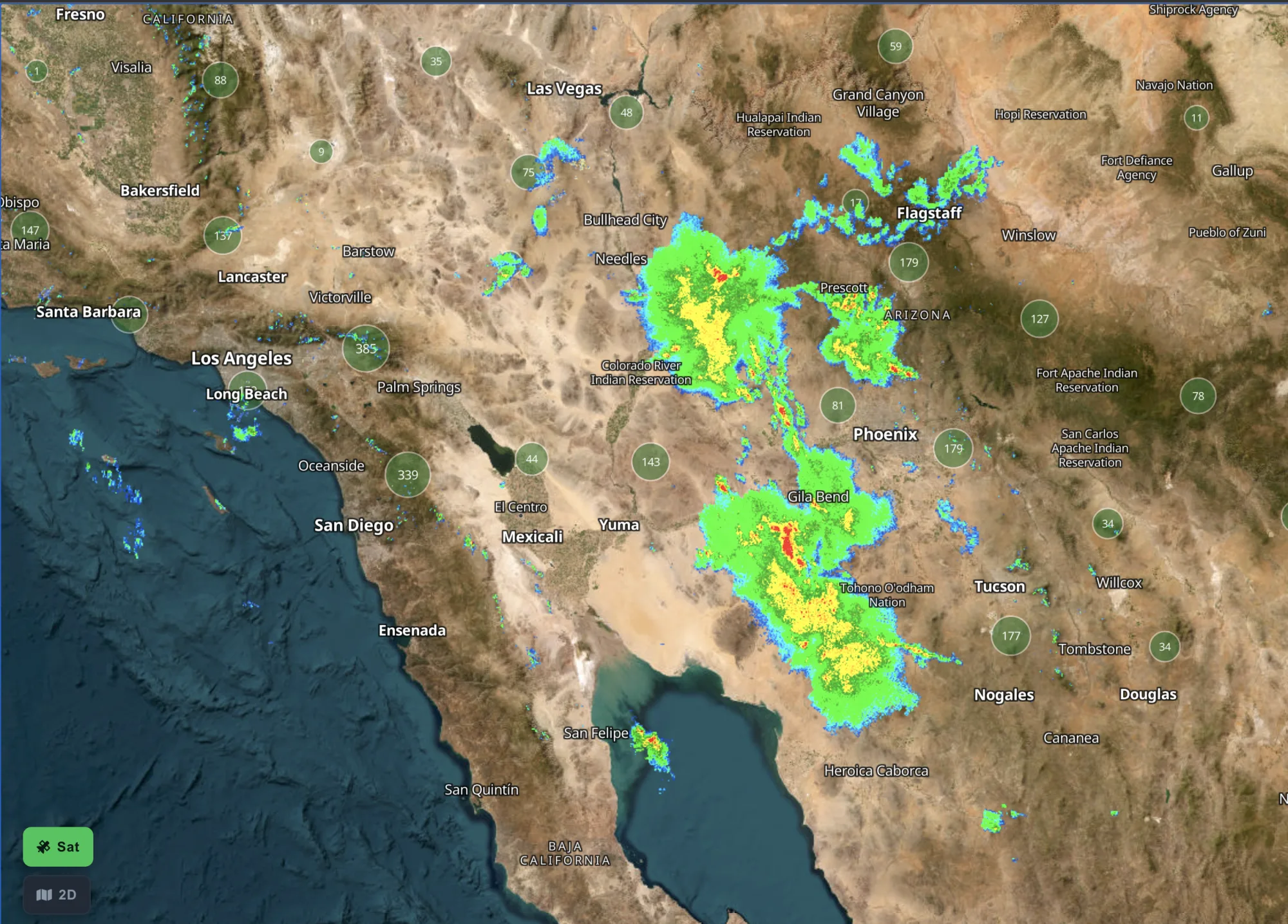
Live radar, on from the first screen
Rain radar runs the moment you open the map, with nothing to switch on and nothing to buy on top: it's in the trial and in every paid plan. National Weather Service watches and warnings sit on the same map.
The forecast comes with you
Plan a route and the seven-day forecast for every point along it is stored on the device: temperature, rain, wind and the overnight low at the campground you're aiming for. Drop off the grid and it still answers.
It tells you before you leave
A thunderstorm at your destination or rain on the pass shows up in the route warnings next to the gates and the closures, while there is still time to leave earlier, go the other way, or stay another night.
Radar is where the rain is now, not where it will be in three hours. Treat it as the picture out the window, and the forecast as the plan.
A detailed trip plan for every day of the trip
Plan your stops and Motocamp builds a day by day plan: the route, the weather, places to stay and what's worth seeing, all worked out for the RV, van or bike you're driving.
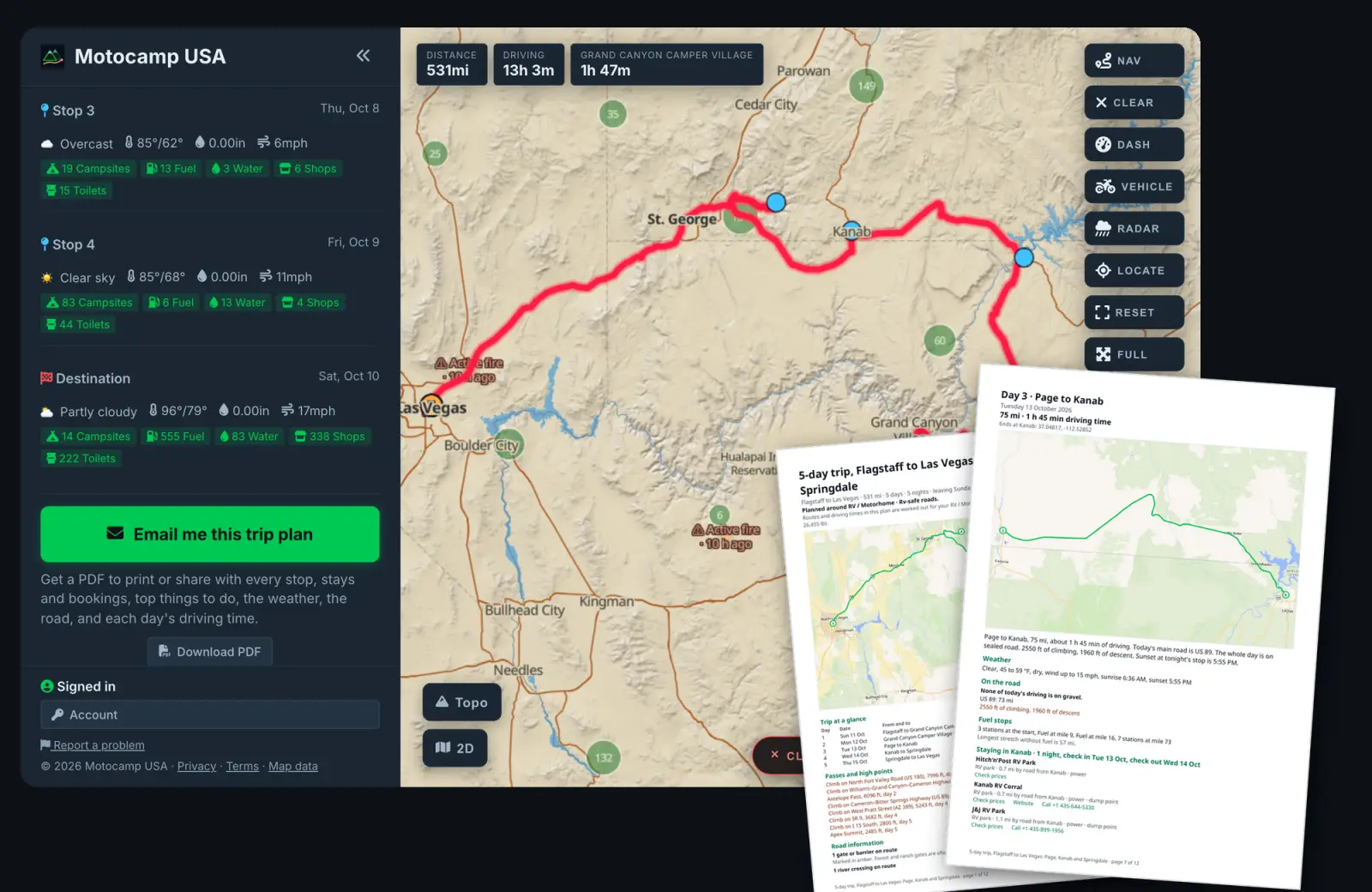
Every day, mapped out
Each day has its own map, the distance and driving time, how much is gravel, the climbs and passes, the fuel stops and the longest gap without one, any road warnings, and the forecast with sunrise and sunset.
Places to stay at every stop
Up to five at each night's stop, picked for your vehicle, with how far each is by road, links to book, the website and the phone number. Put a stop on a place you like and it comes first, with a cheaper and a pricier one beside it.
Things to do, and yours to keep
The top things to do near each stop. The whole plan comes as a PDF you can print, share with whoever's coming, and build again whenever the route changes.
New How much gas each day takes
Tell it your miles per gallon, once. Every route shows the gallons it needs, and the plan splits them by day, so you know where the big fill ups fall. How it works
The PDF adds to the live map and turn-by-turn nav. It doesn't replace them: on the road, the app still guides you.
Plan any trip with A.I. - type in your idea and we'll give you some options
Plan it on the big screen at home or entirely from the phone, then head out with that same phone calling your turns. Every screenshot below is a capture of the running app; the two drawn panels say so on their own bar.
"Four days out of Denver on dirt where I can, dispersed camping only, back by Sunday night."
San Juan dirt loop · 612 mi · 3 nights
Kenosha Pass → Sargents → Lake City → Ouray. Three BLM
dispersed camps, all reachable on graded dirt. 24,000 ft of
climbing, and Cinnamon Pass on day three.
Front Range & South Park · 430 mi · 3 nights
More pavement, easier if the passes are still under snow.
Describe the trip. Get the route.
Tell it what you actually want: "a dirt loop out of Denver with a lunch stop", "four days, dispersed camping only, nothing over 250 miles a day". It comes back with real routes built from the same map: actual campgrounds, actual roads, actual elevation. Not a chatbot describing a trip, a route you can actually take.
In the trial and on every paid plan. 15 plans a day. It already knows what you're driving.
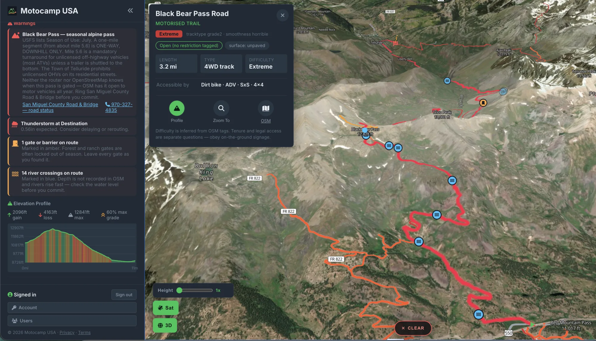
Know the climbing before you're in it
Every route comes with a full elevation profile: total gain and loss, the high point and the steepest grade, charted the whole way along with the nastiest pitches marked in red. You find out a pass is going to hurt at the kitchen table, not at the bottom of it.
This is Black Bear Pass: 2,096 feet of climbing to 12,841, pitches at 60 percent, and the app saying out loud that a mile of it is one-way downhill only, that the season is July, and that the county road office is the one to ring before you commit.
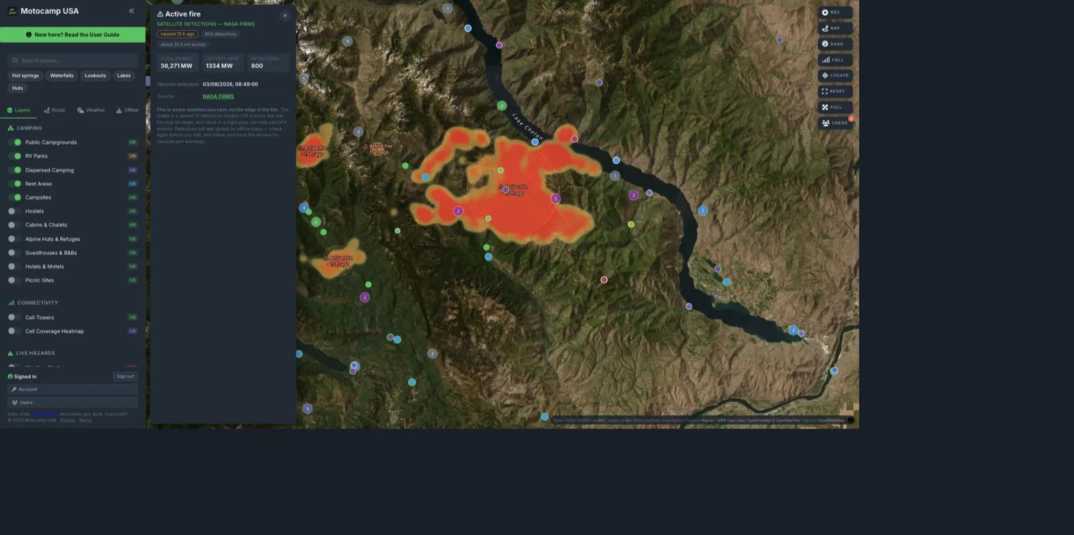
Know what's burning, before you head into it
NASA's satellites cross the United States several times a day and flag where the ground is hot. Fire is on your map from the moment you open it; you don't have to know to switch it on. Tap one for how hot it is, how far the detections spread and how recently it was seen.
It shows where satellites saw heat, not the edge of a fire. One detection covers about 375 m, cloud or a night pass can hide a fire completely, and it won't update offline. Your local fire service and InciWeb stay the authority on evacuations and closures.
- Public Campgrounds
- Dispersed Camping
- BLM Public Lands
- Motorised Trails
- Road Surface
- Cell Coverage Heatmap
- Fire hotspotsLive
- Road Closures13 states
Whose land is it, and can you use it?
Shade the BLM public land to find the free dispersed camping. Turn on motorised trails from the Forest Service travel maps to see what's actually open to a bike or a 4x4. Turn on road surface to know whether that shortcut is pavement, gravel or a rutted two-track before you commit to it.
Flip anything off to declutter. Fewer dots, faster map.
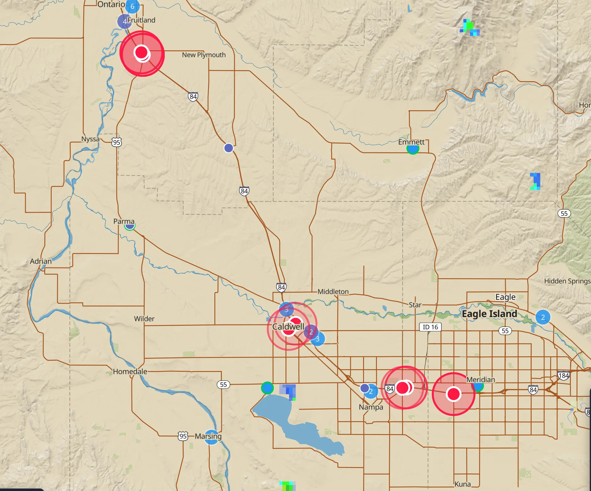
Find out the road is shut before you're standing at it
Full closures (not lane closures, not roadworks) published by state transport departments through a shared federal feed. Plan a route through one and it routes you around it instead, and tells you it did.
About 13 states publish a feed we can read, so coverage is partial and we say so in the app: an empty map means we don't know, never "the road is open". Seasonal gates on the big mountain roads aren't in this feed; where the gate is mapped with its closed months, the route goes round it in season and says so. Check the state DOT or the park before a long committing leg.
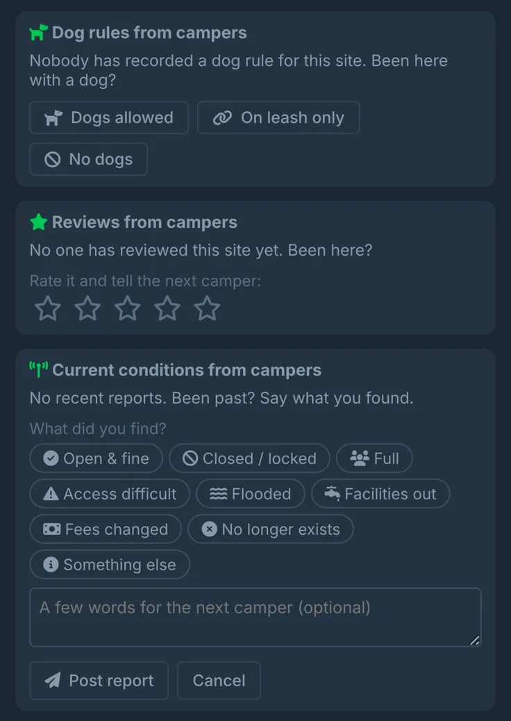
Every campsite takes reviews, and reports of what it's like right now
A rating and a few honest sentences from people who actually slept there; and, separately, what the place is like this week: gate locked, sites flooded, fees changed, camp full. Freedom camping changes fast; a five-year-old review can't tell you the council closed it in March, so the app asks both questions.
One report reads as one camper's word, and the app says so; a run of reports that agree becomes the answer everyone sees. Written notes are screened before other campers see them, links and spam are refused outright, and anything the screen isn't sure about waits for a human.
Everything that decides a route
Public campgrounds, dispersed camping, RV parks, huts and motels, plus the things that actually decide a route.
⛺ Everywhere you can sleep
Public campgrounds, state parks, RV parks, dispersed camping on public land, rest areas, alpine huts, cabins, hostels, B&Bs and motels; one map, one search, and a Save button under the name, so your shortlist follows you from the desktop to the phone.
⭐ What campers say, and whether the dog can come
Every site takes reviews from the people who actually slept there: a rating, and what the next camper should know. Dogs get their own answer, because most campgrounds have never published one. Report what the sign at the gate says and the map remembers it; one report reads as one camper's word, and a run of them that agree becomes the answer everyone sees.
🏜️ Know whose land it is, and whether you're allowed on it
BLM public land shaded on the map, motorised trails from the Forest Service travel maps, and road surface coloured by what it's really made of. Know where you're allowed before you're down the track.
⛽ Fuel, water and the nearest hospital
Fuel stations, drinking water, dump stations, toilets, shops, ATMs, repairs and hospitals, mapped along the route, so an empty tank a hundred miles from town is never a surprise.
💰 Know the gas before you go
Add your miles per gallon and every route shows the gallons it needs, for the trip and for each day, so you know where to fill up.
📶 Know where the signal dies
Cell towers and a coverage heatmap on the map; find the signal when you need it, or deliberately head out of it.
🧭 A route your rig can actually do
Prefer dirt or avoid highways, add stops, and get distance, drive time for the rig you picked, arrival time and an elevation profile before you leave. An RV gets kept off the jeep trails; an enduro bike doesn't.
✨ Describe the trip, and AI plans it
Describe the trip in plain English and get real routes back, built from the same campgrounds and roads as the rest of the map. It plans routes; it won't wander off topic.
📈 How much climbing the day holds
See it before you're in it: total gain and loss, highest point and steepest grade, drawn as a profile along the whole route. The difference between a pleasant afternoon and a bad decision.
🌧️ Weather you can see coming
Rain, wind and temperature along the route, plus National Weather Service alerts and live closures from state DOTs. Live rain radar is on from the moment you open the map, on the trial and on a paid plan alike.
🔥 Active fire, seen from orbit
NASA satellites cross the country several times a day and flag where the ground is burning. Fire sits on your map from the moment you open it. It shows where satellites saw heat, not the edge of a fire; cloud or a night pass can hide one, so keep following your local fire service.
🔎 An answer to "where this weekend?"
One tap for hot springs, waterfalls, lookouts, lakes or backcountry huts near where you're looking. A shortlist worth the detour, not a map you have to read.
🏔️ Read a pass before you're on it
Tilt into 3D to see what a pass actually looks like before you take it; route planning works in 3D too. Over satellite, place names stay upright and readable at any angle, however far you tilt or turn.
📥 The whole app, offline
Download the states you're crossing before you go: vector maps, satellite imagery and 3D terrain, every campground, route planning, and spoken turn-by-turn. No signal required for any of it.
🏁 It knows when you've arrived
Pull into camp and the navigation finishes: guidance stops, the turn banner goes, and you get the day laid out, distance covered, time moving and your average. Left running, it would have kept trying to navigate you to the spot you were standing on.
🚩 Tell us when we're wrong
A fee that changed, a gate that's locked, a road our route shouldn't have taken: report it from the place, the map or the route itself. It goes to us and nobody else, and you hear back in the app once the map has it.
Know where the bars stop.
Coverage drawn on the map before you drive into it, so the last place you can send a message is a decision rather than a discovery.
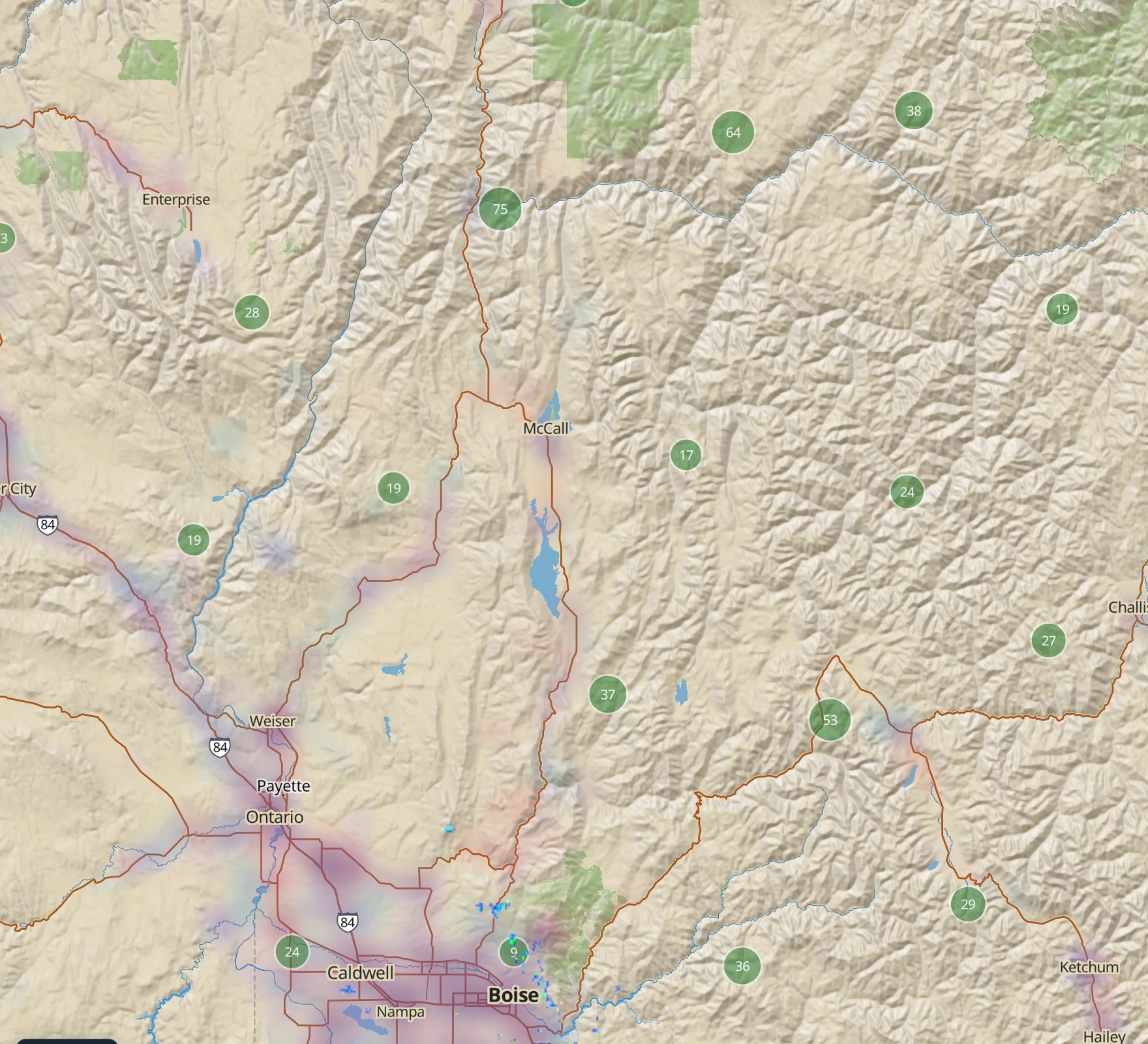
Coverage, by carrier
Built from public tower registrations for the big three networks, drawn as a heat map you can read at a glance: the corridor is covered, the country between is not, and you can see exactly where that changes.
An estimate on every campsite
Open a campground and it tells you what signal to expect there, next to the water, the toilets and the fee. Where we can't tell, it says so instead of guessing.
Why it matters at the end of the day
It decides where you can call a tow, get a forecast, or tell someone you're fine. Pick the camp with a bar of signal, or pick the one without on purpose.
It's an estimate from tower positions, not a carrier's own map and not a promise. Terrain hides signal that a tower suggests you should have, so read the country, not the colour.
The places worth stopping for
Forty-nine food stops from Maine to California, hand-checked and pinned to the road they sit on. Not a restaurant directory: the canyon store every LA motorcyclist knows, a Saturday-only brisket pit, a Route 66 burger stand that has been pranking travellers since 1953.
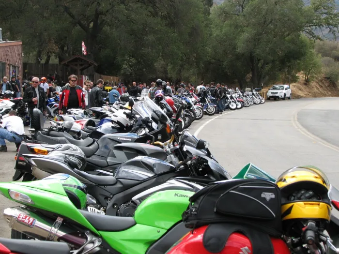
The Rock Store
A 1920s stone roadhouse on Mulholland that became the meeting point for Los Angeles motorcycling. On a Sunday the bikes line the frontage two deep.
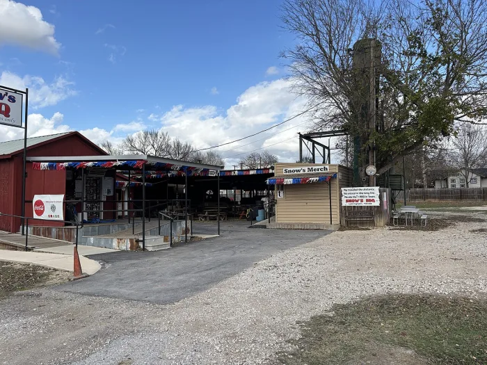
Snow's BBQ
Open Saturday mornings only, until it sells out. Tootsie Tomanetz has been working the pits for decades, and people queue before dawn for the brisket.
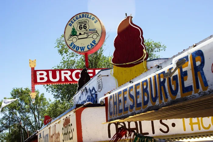
Delgadillo's Snow Cap
A 1953 drive-in built from scrap lumber at the start of the longest unbroken stretch of the Mother Road, run on a straight face and a lifetime of gags.
Every entry names the road it sits on, carries the date it was last checked, and has a report-a-problem link, because a list like this is only worth having if somebody keeps it honest. Switch the layer on under Worth a Stop; it stays off until you ask for it.
Camps only campers know about
Found a good free camp, a quiet pull-in or a dump station that is not in any app? Add it from the map in about a minute. Name it, pick what it is (Free camp, Paid campground, Dispersed camp, Dump station, Drinking water, Shower or Rest area), tick what is there, and it's on the map for every other camper straight away, marked unconfirmed until someone checks it.
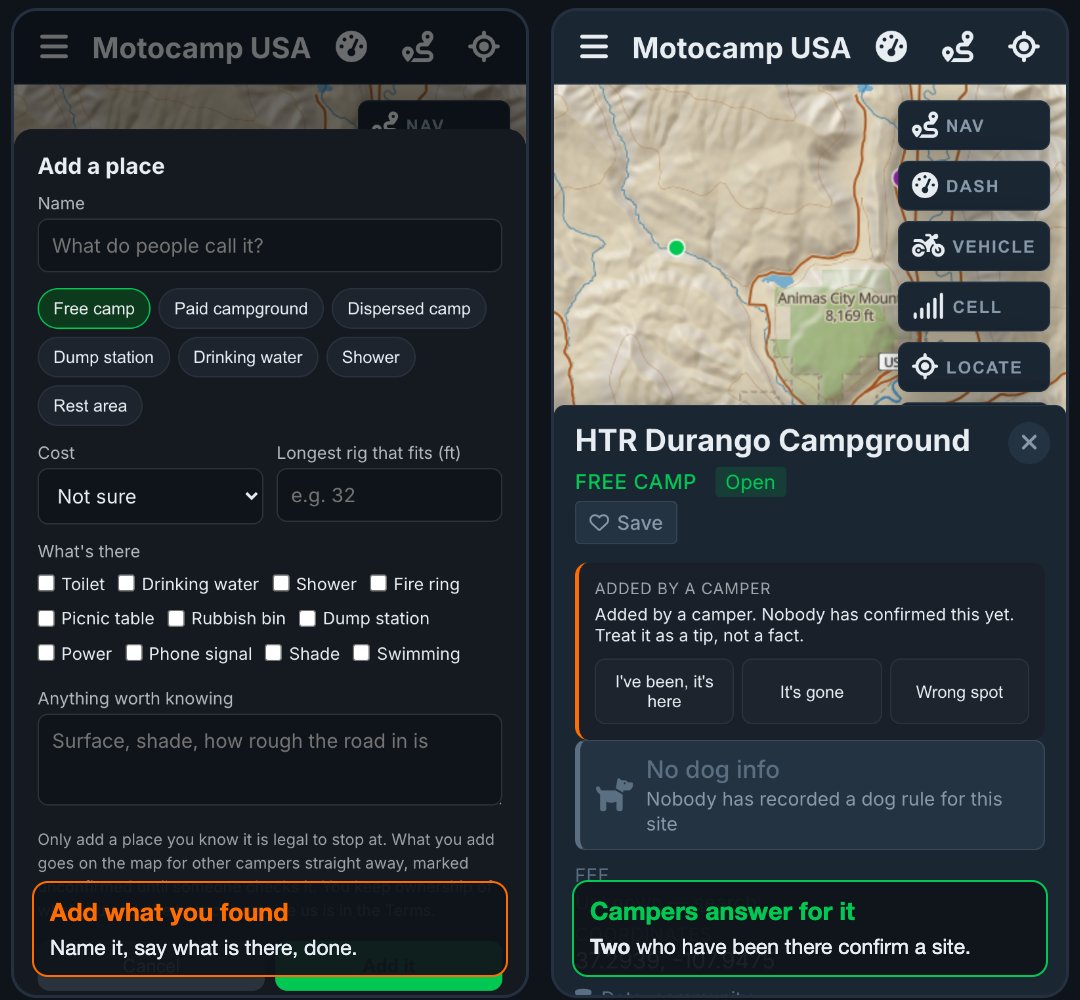
Then anyone who passes can answer for it, which is the part that keeps it honest:
- I've been, it's here
- It's gone
- Wrong spot
Two campers who have actually been there confirm a site; four who are checking from home. Confirmations fade with age, so a camp that closed doesn't stay confirmed forever, and a site campers disagree about is marked disputed rather than quietly dropped. You keep ownership of what you add.
No signal? It all still works.
Download the states you're crossing once, over wifi, and the app stops needing the internet. This matters on the phone, in the places where the bars run out.
🛰️ Satellite and 3D terrain, offline
The satellite imagery and the terrain model come with you, so you can still tilt into 3D and read a pass properly in the middle of the Frank Church.
🔊 The voice keeps talking
Spoken turn-by-turn runs on your phone's own speech engine, so it calls your turns in the dead zones exactly like it does in town. No server, no streaming, no silence.
🧭 Plan a new route with no signal
The router itself is on the phone. Campgrounds, dispersed sites, fuel and water are stored with it, so you can plan tomorrow's route from a campsite with no bars and drive it with spoken turns. Fourteen packs cover all 50 states.
Desktop and phone. No app store.
Motocamp is a website, so there's nothing to download and nothing to update. Open it in a browser and you're in: the big screen at home for planning, the phone in the mount for the drive, the same account, saved routes and saved spots on both.
💻 Plan it on the big screen
Any laptop or desktop browser. Drawing a two-week loop is simply easier with a mouse and a wide map, and the route is on your phone before you stand up.
📱 Take it with you on the phone
Add it to your home screen and it opens like any other app, with its own icon, full screen, no browser bars. iPhone, iPad and Android all work. The first time you open it, a short tour plans a trip in front of you, tilts the map, and hands the app back.
✈️ Fully offline on the phone
Download the states you're crossing and the phone needs no signal at all: map, satellite, 3D terrain, campgrounds, routing and the spoken turns.
- Open motocamp.us in Safari on an iPhone or iPad, or Chrome on Android, and sign in.
- Tap Share then Add to Home Screen on iOS. On Android, tap the three dots then Install app.
- The icon sits with your other apps and opens full screen. Deleting it never touches your account, your subscription or a single saved route.
Free for 14 days. Cancel any time.
Card up front, nothing charged for 14 days. Cancel before day 15 and you pay nothing at all. Then $30 a year, $5 to $70 less than the apps travelers already pay for. They sell a map. This is the trip and the night, rated for your rig.
One account covers both your phones and the laptop. Plan the trip at home, open it on the phone and go.
Cancel any time.
Works out at $2.50 a month.
| Motocamp | $30 / year · 14 days free · route + camp · rated for your rig |
|---|---|
| onX Offroad | $35 Premium · $100 Elite · 7-day trial. You save $5 vs Premium, $70 vs Elite. Trails and parcels. Not a camp planner. Not rated for an RV. |
| Gaia GPS | from $40 / year · Outside+ $90. You save $10 or more. Layers and tracks. The night is a second app. |
| AllTrails+ | $36 / year after a 7-day trial. You save $6. Hiking first. Not built for a loaded rig. |
| REVER PRO | $40 / year. You save $10. Trip tracker and Butler maps. Camps via The Dyrt. No vehicle rating. |
| Calimoto | $80 / year · or $13 / week. You save $50. Twisty paved roads. No dirt. No camp. |
| The Dyrt PRO | $60 / year. You save $30. Camps and discounts. Not a route for your rig. |
| Trails Offroad | $40 / year. You save $10. Trail guides. Not the night, not the highway. |
- One app for the road and the night. They split that across two subscriptions.
- Eight rigs: bike to trailer. The line changes. They do not rate a road for an RV.
- 14 days free. onX and AllTrails give you 7.
- Describe the trip in a sentence. No other mainstream map does that.
- Offline satellite, 3D, camps and spoken turns. One download.
Prices from each brand’s own site, August 2026. OsmAnd can cost less if you only want a DIY map.
Payments handled by Stripe, the same processor used by Amazon, Shopify and Instacart; your card details go straight to them and never touch our servers. Cancel any time in a couple of taps, and if you want a refund, just ask and you'll get one.